-
Copper
Mine and Mill Tailings Characterization and Seepage
Analysis, Central Arizona
Situation
An
assessment of the potential groundwater quality impacts
of drainage from over 2 square miles of copper mine
and mill tailings was required for permitting mine
operations. Potential sources of seepage and the acid
generating potential of the tailings needed to be
defined and appropriate control technologies identified.
Large portions of the tailings were inundated by acidic
water from on-going remedial activities.
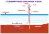
Conceptual Diagram of a Constant Head Seepometer System
Hydro
Geo Chem's Approach
We
determined early in the project that potential water
quality impacts from the tailings would be strongly
affected by their depositional history and by natural
attenuation processes occurring in the underlying
bedrock aquifer. The three-dimensional structure,
grain-size distribution, and mineralogy of the tailings
were reconstructed from aerial photographs, topographic
maps, and operating histories of 90 years of mine
activities. Computer-generated solid models and images
were then used to guide field investigations.
In-situ
cone penetrometer technology was used to conduct a
screening-level investigation of the tailings resulting
in a focused use of more expensive drilling and well
construction methods. The major and trace element
chemistry of subsurface solutions were used to define
sources of seepage. Measurements of seepage, infiltration,
permeability, moisture content, and pressure were
made to define the hydraulic conditions in the tailings.
Numerical models were constructed to simulate saturated
and unsaturated flow in three-dimensions to quantify
drainage rates and mass loadings to the underlying
aquifer. The natural attenuation capacity of the underlying
bedrock aquifer was assessed using appropriate geochemical
models.
Results
The
investigation concluded that future drainage from
the tailings would have a minimal impact on the underlying
aquifer because of relatively slow drainage rates
and natural attenuation in the bedrock. These findings
were incorporated into the aquifer protection permit
application. The models are also being used as management
tools to develop operating plans and evaluate remedial
options.